
(This is the second part of our series, following the article exploring France’s success with open-source GIS)
Canada’s geospatial systems are at a crossroads. Technology is moving fast, and the pressure is on for more efficient, flexible solutions. It’s time for Canada to think seriously about modernizing its geospatial infrastructure. Open-source GIS could be a game-changer — cutting costs, making everything work together better, and giving developers the freedom to create what we actually need.
This also ties into the larger conversation about creating systems that truly work for Canada and protecting our digital sovereignty. With shifting trade alliances and global politics in a constant flux now, it’s becoming clear that control over our own digital infrastructure is more important than ever.
This concern was echoed by multiple thought leaders at GeoIgnite 2025, where panelists and keynote speakers underscored the need for Canada to take greater ownership of its geospatial infrastructure and reduce reliance on foreign technologies.
France is the best example of how a clear commitment to open-source GIS has paid off. With over 1,000 local authorities publishing open geodata and a 19% year-over-year increase in government data sharing, the French model demonstrates how a national strategy can drive real change.
This change didn’t come overnight, but is the result of a more than a decade-long strategy — a commitment that started back in 2012 when then-Prime Minister Jean-Marc Ayrault issued a directive calling on public administrations to prioritize open-source software. Since then, over the past 13 years, the French government has put significant resources into supporting open-source initiatives.
The result? A thriving ecosystem that not only helps the public sector but also empowers local developers and citizens.
Why Open Source?
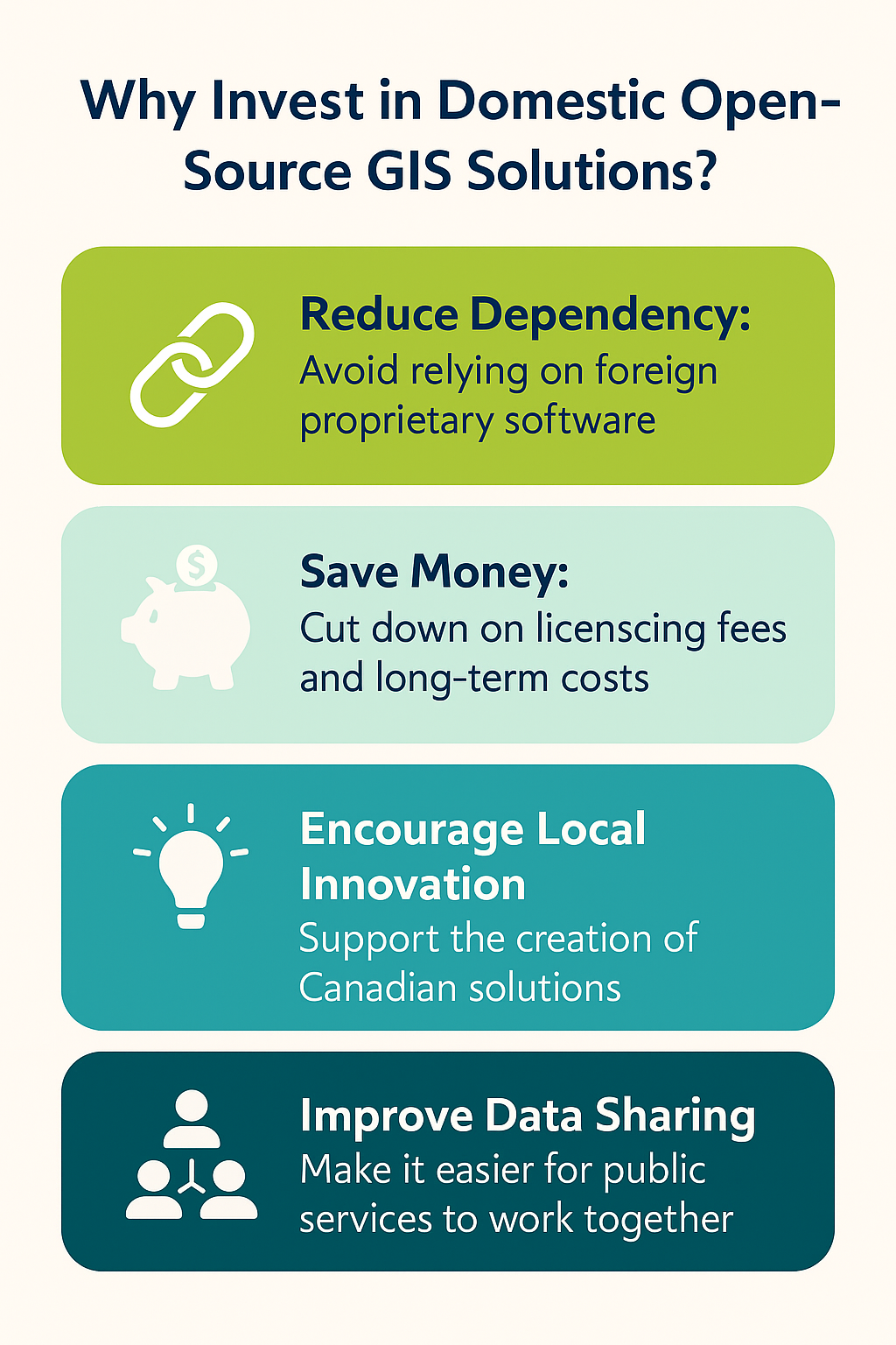 Open-source GIS not only offers financial benefits by reducing licensing fees but also encourages more flexible and transparent systems. This aligns with the growing global trend of governments embracing open-source solutions to increase control over their geospatial data and enhance service delivery. From Germany, to the UK, Australia, South Korea, Brazil, India, governments are pushing for new software to be built on open standards, and there’s a growing emphasis on transitioning existing systems to open-source platforms.
The aim is clear: reduce costs, boost digital sovereignty, and create a more resilient technological foundation. This global trend demonstrates how open-source software is no longer just a nice-to-have, but a critical element in modernizing public sector infrastructure.
Beyond financials, open-source GIS provides greater flexibility. The software is often more intuitive and feature-rich, tailored to the needs of end-users. It’s highly customizable, supported by an active community of developers and users, and built with up-to-date standards for interoperability. This means that open-source GIS can seamlessly integrate with other systems and read a variety of file formats — reducing the barriers to adoption and making it easier for public services to work together.
Moreover, the extensibility of open-source software allows for continuous enhancement, enabling governments to add new features and capabilities as needed.
As digital sovereignty becomes a bigger deal globally, it’s clear Canada needs to step up — and the time to act is now.
Canada: Fragmented, But Room for Growth
Canada recognizes the value of open-source software, but our approach is largely inconsistent. We have made data more accessible, but we haven’t built the open-source GIS tools to back it up.
The key framework for open source was the 2018 Directive on Management of Information Technology, which has since been replaced by the Policy on Service and Digital and the Directive on Service and Digital that came into effect on April 1, 2020. These policies push for using open standards and open-source software in public services to make them more accessible and interoperable.
The Policy on Service and Digital also has a clear message for departments: use open standards and solutions whenever it makes sense. To help with this, the government released the Guide for Using Open Source Software.
But here’s the catch: none of these policies actually make open-source mandatory. They just suggest it when it’s practical. That’s a big difference from how France approaches it, where open source is often the default.
Where Canada has made real progress is in making geospatial data more accessible. Back in 2014, the Open Government Directive introduced the idea that public data should be “open by default” unless restricted by privacy or security concerns. The goal was simple: enhance transparency and public engagement while making data available in reusable formats.
One of the key projects that came out of this is Open Maps, a platform that brings together geospatial data from different government sources. Another important effort is the GeoBase Initiative. It’s a partnership between federal, provincial, and territorial governments to provide high-quality geospatial data without any cost. The principal is to “collect once, use many times” to avoiding duplication. Then there’s the Canadian Geospatial Data Infrastructure (CGDI) which helps make data sharing easier across the country.
One notable initiative is Geo.ca, which provides access to high-quality, publicly available geospatial data and serves as a key resource for federal, provincial, and territorial governments. It aligns with the broader goal of enhancing transparency, public engagement, and data-sharing across the country. While Geo.ca plays an important role in data accessibility, there’s still no coordinated national strategy to build open-source GIS tools specifically for public administration.
One of the few examples is Whitebox Geospatial Analysis Tools (Whitebox GAT), an open-source GIS tool developed at the University of Guelph. While it has received recognition, it’s more of an academic project than a national effort. There’s no coordinated plan to build open-source GIS tools specifically for public administration.
The result: even though a lot of geospatial data is openly available, people still often use commercial software to work with it. That means there’s still a heavy reliance on proprietary GIS tools. It’s a bit of a mismatch — open data, but closed software, which limits the potential for fully open, interoperable geospatial ecosystems.
Lessons for Canada’s Digital Future
For Canadian policymakers and tech leaders, France’s experience offers a masterclass in digital transformation. The French success story hinges on four key elements:
- First, policy consistency. France didn’t just start encouraging open-source adoption. It was mandated through clear legislation. Such an approach created the certainty that developers and institutions need for long-term planning.
- Second, investment to back up policy. By funding projects like OrbisGIS and Constellation-SDI, France ensured that open-source alternatives could mature into enterprise-grade solutions.
- Third, pragmatism. France’s willingness to use proprietary tools where necessary ensures the public sector does not lose out on technological advancements. The goal is not to eliminate commercial software but to minimize reliance on it.
- Finally, active engagement with the public converts users into useful contributors. Projects like Panoramax are a huge success because they tap into civic pride and professional expertise, which in turn creates a virtuous cycle of improvement.
The Path Forward
Digital maps and geospatial systems are now a cornerstone of our digital infrastructure. During disasters like floods or wildfires, these tools are critical for coordinating emergency responses and directing resources where they’re needed most. When it comes to urban planning, decisions about where to place new transit lines or hospitals rely heavily on accurate geospatial data to ensure those choices are sound and effective.
France recognized this reality years ago. Their adoption of open-source GIS is much more than cost saving — it’s about reshaping the way we control the digital infrastructure that increasingly influences our physical world.
Canada can learn a lot from France’s approach. We don’t have to copy it, but we can certainly draw from their insight that geospatial data is too important to leave entirely in external hands. Open-source solutions give Canadians the chance to take control of their digital geography, all while encouraging homegrown innovation.
The real question for Canadian policymakers isn’t whether we can afford to invest in open-source GIS — it’s whether we can afford not to.


